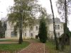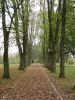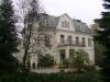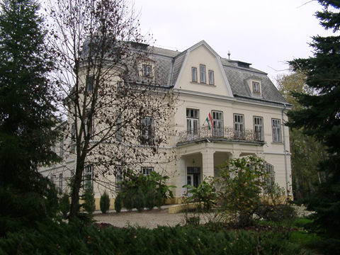
Zákány község belterületén az általános iskola körül 5 ha nagyságú park díszlik. Ez a park korábban Zichy tulajdon volt. Kertművészeti szempontból is értékes történelmi kert. Nagyszámú és értékes növényanyagaiból érdemes megemlíteni a pátrányfenyőt, a kaukázusi jegenyefenyőt, a 30 fából álló hársfasétányt, a vörösfenyőt, a tiszafát, a harnisciprust, a lucfenyőcsoportokat, a keleti tujákat, a malonyai tujákat, a nyíreket stb.
--------------------------------------------
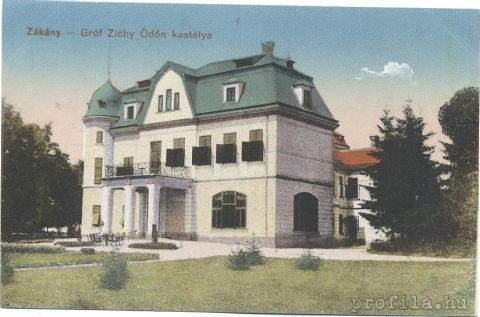
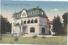
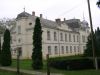
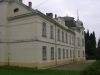
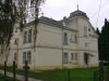
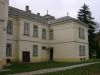
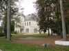
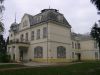
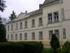
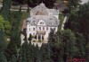
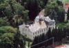
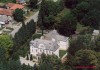
A település utolsó földbirtokosa Zichy Ödön volt, aki 1911-ben építette kastélyát, amelyben ma az egyik általános iskola működik. Parkjában védett növények vannak. Országos jelentőségű természetvédelmi területe a 19 ha-os Tölös-hegy (Látóhegy). Kastélypark Ez a park korábban Zichy-tulajdon volt, ma az általános iskola számára teremt szép és hangulatos környezetet. Értékes fái a páfrányfenyő, a kaukázusi jegenyefenyő, a tiszafa, a malonyai tuják és a hamisciprusok. Külön figyelmet érdemel a 30 fából álló hársfa sétány. A park kertművészeti szempontból is értékes. |
Address: Zákány, Szabadság út 92. |
| Openness for the public: |
| Data sheet of the garden |
|
| | |
| Garden identificaton number: | 1245 |
| Garden name: | Zichy-kastély és kertje |
| Present size of the garden: | 5,3 ha |
| Country: | Hungary |
| County: | Somogy |
| Settlement: | Zákány |
| Street: | Szabadság út 92. |
| House number: | |
| Phone: | 82/709-059 |
| Fax: | |
| Email: | zakanyhiv@t-online.hu |
| Web site: | www.zakany.hu/http://http://http://http://www.kastelyok-utazas.hu/Lap.php?cId=968&kId=968http://http://http:// |
| WGS84 latitude coordinate: | 46.252048 |
| WGS84 longitude coordinate: | 16.953278 |
| National grid X coordinate: | |
| National grid Y coordinate: | |
| Land ownership record: | |
| Owner: | n.a. , , , , , , |
| Manager(s), renter(s): | n.a. , , , , , , |
| User: | , |
| Present function, usage: | n.a. |
| Openness for the public: | |
| Opening hours: | |
| Visitors per year: | 1990: 1991: 1992: 1993: 1994:
1995: 1996: 1997: 1998: 1999:
2000: 2001: 2002: 2003: 2004:
2005: 2006: 2007: 2008: 2009:
2010: 2011: 2012: 2013: 2014:
2015: 2016: 2017: 2018: 2019:
2020: 2021: 2022: 2023: 2024:
2025: |
| Garden historical data |
|
| Type: | |
| Style, character: | |
| Special value: | |
| Importance, value: | regional importance |
| Original size of the garden: | ha |
| Year(s) of garden planting: | -
|
| Present state, condition of the garden: | |
| Present structure of the garden: | |
| : | |
| Plant condition: | |
| Plans, maps: | |
| Historic county name: | |
| Historic Monument Data: |
|
| Historic monument number(s): | |
| Historic monument type: | |
| Resolution of historic monument: | |
| Description of built objects |
|
| Main building description: | |
| Building time of the principal building: | |
| Condition of the principal building: | |
| Present function of the main building: | |
| Other buildings list: | |
| Main building style: | |
| Nature Conservation data: |
|
| Type of nature conservation: | helyi védettségű terület |
| Nature Conservation code : | 1/1985. (X.1.) Tr. |
| Natuara2000 area code: | |
| Landscape Data: |
|
| Morphology: | |
| Hydrology: | |
| Plant geography: | |
| Soil: | |
| Climate: | |
| Visual connections: | |
| Landscape Character Area name: | |
| Landscape Character Area type: | |
| | |
| Other: | |
| | |
| Associated persons: | |
| Bibliography: | |
| |
| This page edited by: | kollanyi5, |
| Last modified by: | kollanyi5 2009-08-14 |
|