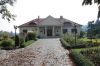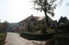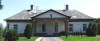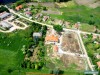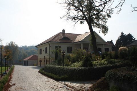
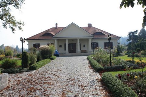
A klasszicista stílusú, földszintes, eredetileg U alakú épületet a XIX. század elején emeltette Puky Márton. Érdekessége a domboldalon álló kúriának, hogy a kert felőli oldala emeletes. A Perczel család tulajdonába a XIX.században került, a család tagjai az 1848-49-es szabadságharc tábornokának, Perczel Mórnak egyenes ági leszármazottai voltak. A hagyomány szerint Katona József a Pukay család vendégeként itt írta a Bánk bán néhány részletét. Később a bonyhádi Perczel család birtoka volt, és róluk kapta mai elnevezését is. A II. világháború után a helyi tanács központi konyhája és étkezdéje kapott helyet benne, mely az önkormányzat kezelésébe ment át a rendszerváltást követően. A kúria magán tulajdonba került, az épületet igényesen eredeti állapotában helyreállították, a park rehabilitáziója is elkészült. A kúria lakás célját szolgálja. |
Localitate: Gomba |
| Openness for the public: |
 2008:10:16 12:32:29 http://muemlekem.hu/muemlek?id=7041 |
| Data sheet of the garden |
|
| | |
| Indicatorul gradinii: | 396 |
| Numele gradinii: | Perczel-kúria és kertje |
| Suprafata actuala a parcului: | ha |
| Tara: | Ungaria |
| Judetul: | Pest |
| Localitatea: | Gomba |
| Strada: | |
| Numarul: | |
| Telefon: | |
| Fax: | |
| Email: | |
| Internet: | www.gomba.hu/latnivalok.phphttp://http://www.kastelyok-utazas.hu/Lap.php?cId=1500&kId=1500http://http://http://muemlekem.hu/muemlek?id=7041http:// |
| Latitudine: | 47.367839 |
| Longitudine: | 19.534979 |
| National grid X coordinate: | |
| National grid Y coordinate: | |
| Land ownership record: | |
| Proprietar: | , , , , |
| Manager(s), renter(s): | , , , , |
| Folosinta: | , |
| Mod de folosinta actual: | |
| Openness for the public: | |
| Opening hours: | |
| Visitors per year: | 1990: 1991: 1992: 1993: 1994:
1995: 1996: 1997: 1998: 1999:
2000: 2001: 2002: 2003: 2004:
2005: 2006: 2007: 2008: 2009:
2010: 2011: 2012: 2013: 2014:
2015: 2016: 2017: 2018: 2019:
2020: 2021: 2022: 2023: 2024:
2025: |
| Date legate de istoria gradinii |
|
| Type: | |
| Stilul gradinii: | |
| Special value: | |
| Valoarea, importanta gradinii: | importanta locala |
| Marimea originala: | ha |
| Data amenajarii gradinii: |
|
| Situatia actiuala a gradinii: | |
| Structura actuala a gradinii: | |
| : | |
| Conditia vegetatiei: | |
| Planuri: | |
| Historic county name: | |
| Historic Monument Data: |
|
| Numarul monumentului: | 7029 |
| Tipul monumentului: | |
| Resolution of historic monument: | |
| Date referitoare la cladiri, constructii |
|
| Descrierea cladirii principale: | |
| Data edificarii cladirii principale: | |
| Situatia actuala a cladirii principale: | |
| Present function of the main building: | |
| Lista cladirilor anexe: | |
| Stilul cladirii principale: | |
| Nature Conservation data: |
|
| Tipul protectiei naturale (peisagere): | |
| Codul protectiei naturale (peisagere): | |
| Codul ariei Natura 2000: | |
| Landscape Data: |
|
| Morfologie: | |
| Hidrologie: | |
| Geografie vegetala: | |
| Pedologie: | |
| Clima: | |
| Legaturi vizuale: | |
| Landscape Character Area name: | |
| Landscape Character Area type: | |
| | |
| Altele: | |
| | |
| Associated persons: | |
| Bibliografie: | |
| |
| This page edited by: | kollanyi5, |
| Last modified by: | kollanyi5 2009-04-14 |
|