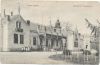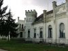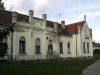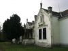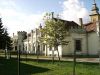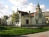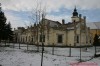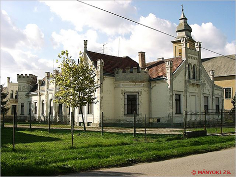
A mai kastély elődjét a Sajnovics család emeltette a XVII. század végén, XVIII. század elején. Később a Batthyány, majd a Dreher család tulajdonába került, akik a XIX. század végén historizáló-romantikus Tudor-stílusban átépítették.
------------------------------------
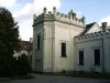
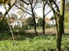
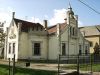
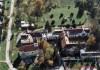
1687-ben lett birtokos Sajnovics Mátyás, aki a török pusztítás után az új falut alapította, s a családi kastélyt is építtette. Itt született unokája, Sajnovics János jezsuita pap, nyelvész és csillagász, aki jezsuita rendbe való felvétele után, testvérére hagyta a kastélyt. A Sajnovics család kihalása után a Batthyányi család lett a tulajdonos, akik a kastélyt jelentősen kibővítik. A Bathyányi családtól aztán a Dréher család tulajdonába kerül, akik átalakítják, s elnyeri jelenlegi formáját. A II. világháború után államosítják, s szociális otthont alakítanak ki benne. A jelenlegi tulajdonosa (a Főváros) magárahagyatva, üresen hagyja pusztulni! Kicsit tovább sétálva, megnézhetjük az egyik volt gazdasági épület magánkézbe kerülése utáni gyönyörű felújítását.
wiki.utikonyvem.hu
|
Address: Tordas, Sajnovics tér 5. |
| Openness for the public: engedéllyel |
| Data sheet of the garden |
|
| | |
| Garden identificaton number: | 1171 |
| Garden name: | Sajnovics-kastély és parkja |
| Present size of the garden: | 5,4 ha |
| Country: | Hungary |
| County: | Fejér |
| Settlement: | Tordas |
| Street: | Sajnovics tér 5. |
| House number: | |
| Phone: | 22/467-538 |
| Fax: | |
| Email: | |
| Web site: | wiki.utikonyvem.hu/hu/index.php?title=Sajnovics-kastély_(Tordas)http://http:// |
| WGS84 latitude coordinate: | 47.341411 |
| WGS84 longitude coordinate: | 18.751173 |
| National grid X coordinate: | |
| National grid Y coordinate: | |
| Land ownership record: | |
| Owner: | fővárosi önkorm. , , |
| Manager(s), renter(s): | szociális otthon , , |
| User: | , |
| Present function, usage: | szociális otthon |
| Openness for the public: | engedéllyel |
| Opening hours: | |
| Visitors per year: | 1990: 1991: 1992: 1993: 1994:
1995: 1996: 1997: 1998: 1999:
2000: 2001: 2002: 2003: 2004:
2005: 2006: 2007: 2008: 2009:
2010: 2011: 2012: 2013: 2014:
2015: 2016: 2017: 2018: 2019:
2020: 2021: 2022: 2023: 2024:
2025: 2026: |
| Garden historical data |
|
| Type: | |
| Style, character: | |
| Special value: | |
| Importance, value: | regional importance |
| Original size of the garden: | ha |
| Year(s) of garden planting: | -
|
| Present state, condition of the garden: | |
| Present structure of the garden: | |
| : | |
| Plant condition: | |
| Plans, maps: | |
| Historic county name: | |
| Historic Monument Data: |
|
| Historic monument number(s): | 1743 |
| Historic monument type: | műemlék jellegű |
| Resolution of historic monument: | |
| Description of built objects |
|
| Main building description: | |
| Building time of the principal building: | |
| Condition of the principal building: | |
| Present function of the main building: | |
| Other buildings list: | |
| Main building style: | |
| Nature Conservation data: |
|
| Type of nature conservation: | |
| Nature Conservation code : | |
| Natuara2000 area code: | |
| Landscape Data: |
|
| Morphology: | |
| Hydrology: | |
| Plant geography: | |
| Soil: | |
| Climate: | |
| Visual connections: | |
| Landscape Character Area name: | |
| Landscape Character Area type: | |
| | |
| Other: | |
| | |
| Associated persons: | |
| Bibliography: | |
| |
| This page edited by: | kollanyi5, |
| Last modified by: | kollanyi5 2009-06-27 |
|