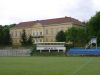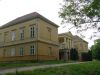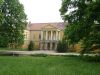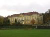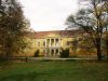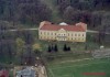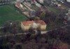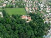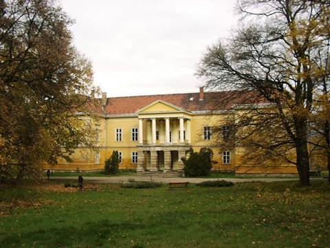
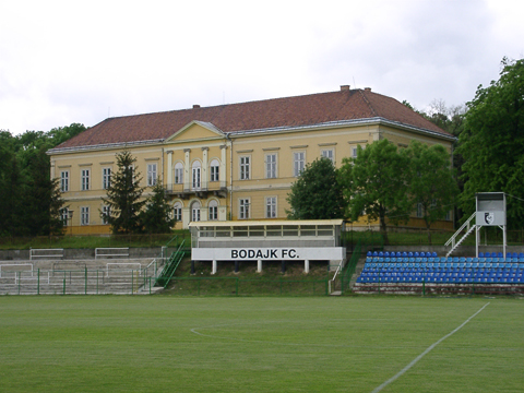
A kastély teljesen elhagyatott, fiatalok tanya helye, elmondásuk szerint évek óta üres, elhagyatott épület. A park is pusztulás sorsára jutott. Az épületen emléktábla tanúsága szerint 1964-ben volt utoljára teljesen felújítva, jelenlegi sorsáról nem sikerült hitelt érdemlő információt beszerezni. A fiatalok szerint egy új tulajdonosa van, aki a kastéllyal együtt a sportpályát megvásárolta, de a tervekről semmit nem tudnak.
http://www.kastelyok-utazas.hu

A mai kastély helyén egykor egy kisebb kúria állt, melyet minden bizonnyal Hochburg Domonkos báró építtetett. Báró Miske József 1837-ben vette bérbe az uradalmat. A mai kastélyt nem sokkal a bérbevétel után ő kezdte el építtetni, a munkálatok 1839-re fejeződtek be. A II. világháború során a kastély megsérült, helyreállítása 1964-ben fejeződött be. A településen Fehérvárcsurgó felé forduljunk, majd a Sportpálya feliratú tábla által jelzett irányba térjünk le. Az út egészen a kastélyhoz visz. Ablakai betörve, elhagyatottan omladozik, ám gyönyörű, 6 hektáros őspark övezi, faritkaságokkal. |
Address: Bodajk, Petőfi u. 93. |
| Openness for the public: szabadon |
 2004:05:08 13:49:33 © M??nyoki Zsolt |
| Data sheet of the garden |
|
| | |
| Garden identificaton number: | 154 |
| Garden name: | Hochburg-Lamberg-kastély parkja |
| Present size of the garden: | 6 ha |
| Country: | Hungary |
| County: | Fejér |
| Settlement: | Bodajk |
| Street: | Petőfi u. 93. |
| House number: | |
| Phone: | 22-410-001 |
| Fax: | |
| Email: | |
| Web site: | varakutjan.gportal.hu/gindex.php?pg=22091542http://http://http://http://http://http://http://http://http://http:// |
| WGS84 latitude coordinate: | 47.318345 |
| WGS84 longitude coordinate: | 18.237906 |
| National grid X coordinate: | |
| National grid Y coordinate: | |
| Land ownership record: | |
| Owner: | , , , , , , , , , , |
| Manager(s), renter(s): | , , , , , , , , , , |
| User: | , |
| Present function, usage: | felújítás alatt |
| Openness for the public: | szabadon |
| Opening hours: | |
| Visitors per year: | 1990: 1991: 1992: 1993: 1994:
1995: 1996: 1997: 1998: 1999:
2000: 2001: 2002: 2003: 2004:
2005: 2006: 2007: 2008: 2009:
2010: 2011: 2012: 2013: 2014:
2015: 2016: 2017: 2018: 2019:
2020: 2021: 2022: 2023: 2024:
2025: 2026: |
| Garden historical data |
|
| Type: | |
| Style, character: | Classical/English landscape garden |
| Special value: | |
| Importance, value: | regional importance |
| Original size of the garden: | ha |
| Year(s) of garden planting: | -
|
| Present state, condition of the garden: | |
| Present structure of the garden: | |
| : | |
| Plant condition: | |
| Plans, maps: | |
| Historic county name: | |
| Historic Monument Data: |
|
| Historic monument number(s): | 1643 |
| Historic monument type: | műemlék, műemléki környezet |
| Resolution of historic monument: | |
| Description of built objects |
|
| Main building description: | |
| Building time of the principal building: | |
| Condition of the principal building: | |
| Present function of the main building: | |
| Other buildings list: | |
| Main building style: | |
| Nature Conservation data: |
|
| Type of nature conservation: | |
| Nature Conservation code : | |
| Natuara2000 area code: | |
| Landscape Data: |
|
| Morphology: | |
| Hydrology: | |
| Plant geography: | |
| Soil: | |
| Climate: | |
| Visual connections: | |
| Landscape Character Area name: | |
| Landscape Character Area type: | |
| | |
| Other: | 1 |
| | |
| Associated persons: | |
| Bibliography: | |
| |
| This page edited by: | Bal??zs, kollanyi5, |
| Last modified by: | kollanyi5 2009-05-17 |
|