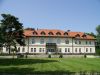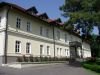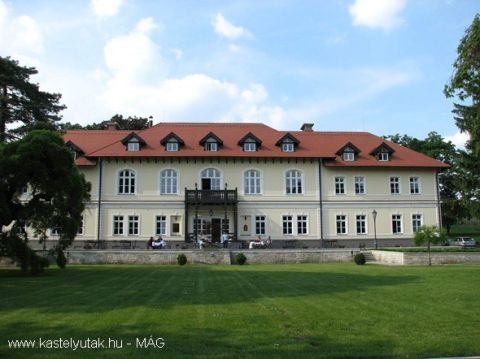
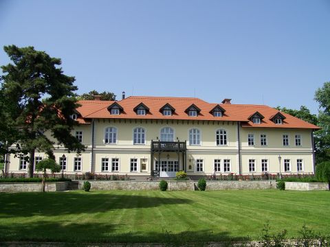
A Terézia-dűlőben található volt királyi kastély és borház a 19. században, eklektikus stílusban épült.
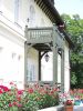
Parkban szabadon álló, téglalap alaprajzú, egyemeletes kastély, kontyolt nyeregtetővel. Az épület öttengelyes középső része magasabb a csatlakozó szárnyaknál. A déli homlokzat közepe előtt faszerkezetű tornác áll.
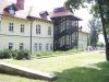
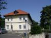
A kastélytól északra új "U" alaprajzú épület áll, mely magába foglalja a téglalap alaprajzú borházat. A kastélytól dél-nyugatra átalakított melléképület, a parkban számtalan újabb lakás és üzemi épület található.
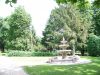
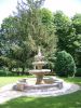
A kastély és parkja szépen rendbentartott, felújított, jelenleg kastélyszállóként és különböző rendezvények színhelyeként üzemel.
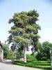
A park értékes, idős fái: kocsányos tölgy, törökmogyoró, fekete fenyő. |
Address: Tarcal (Terézia-dűlő) |
| Openness for the public: a park szabadon látogatható |
 2010:06:12 15:09:51 |
| Data sheet of the garden |
|
| | |
| Garden identificaton number: | 2277 |
| Garden name: | Királyi kastély és borház |
| Present size of the garden: | ha |
| Country: | Hungary |
| County: | Borsod-Abaúj-Zemplén |
| Settlement: | Tarcal (Terézia-dűlő) |
| Street: | |
| House number: | |
| Phone: | |
| Fax: | |
| Email: | |
| Web site: | www.kastelyutak.hu/index.php?option=com_content&task=view&id=395&Itemid=434http://http://http://http://http://http://muemlekem.hu/muemlek?id=3221#44022http://http://http://http://http:// |
| WGS84 latitude coordinate: | 48.133330 |
| WGS84 longitude coordinate: | 21.350000 |
| National grid X coordinate: | |
| National grid Y coordinate: | |
| Land ownership record: | 14,18 |
| Owner: | , , , , , , , , , , |
| Manager(s), renter(s): | , , , , , , , , , , |
| User: | , |
| Present function, usage: | kastélyszálló |
| Openness for the public: | a park szabadon látogatható |
| Opening hours: | |
| Visitors per year: | 1990: 1991: 1992: 1993: 1994:
1995: 1996: 1997: 1998: 1999:
2000: 2001: 2002: 2003: 2004:
2005: 2006: 2007: 2008: 2009:
2010: 2011: 2012: 2013: 2014:
2015: 2016: 2017: 2018: 2019:
2020: 2021: 2022: 2023: 2024:
2025: 2026: |
| Garden historical data |
|
| Type: | |
| Style, character: | |
| Special value: | |
| Importance, value: | local importance |
| Original size of the garden: | ha |
| Year(s) of garden planting: |
|
| Present state, condition of the garden: | |
| Present structure of the garden: | |
| : | |
| Plant condition: | jó, gondozott |
| Plans, maps: | |
| Historic county name: | |
| Historic Monument Data: |
|
| Historic monument number(s): | 9870 |
| Historic monument type: | |
| Resolution of historic monument: | |
| Description of built objects |
|
| Main building description: | |
| Building time of the principal building: | |
| Condition of the principal building: | |
| Present function of the main building: | |
| Other buildings list: | |
| Main building style: | |
| Nature Conservation data: |
|
| Type of nature conservation: | |
| Nature Conservation code : | |
| Natuara2000 area code: | |
| Landscape Data: |
|
| Morphology: | |
| Hydrology: | |
| Plant geography: | |
| Soil: | |
| Climate: | |
| Visual connections: | |
| Landscape Character Area name: | |
| Landscape Character Area type: | |
| | |
| Other: | |
| | |
| Associated persons: | |
| Bibliography: | |
| |
| This page edited by: | kollanyi5, Nagy Nikoletta, |
| Last modified by: | Nagy Nikoletta 2010-07-16 |
|