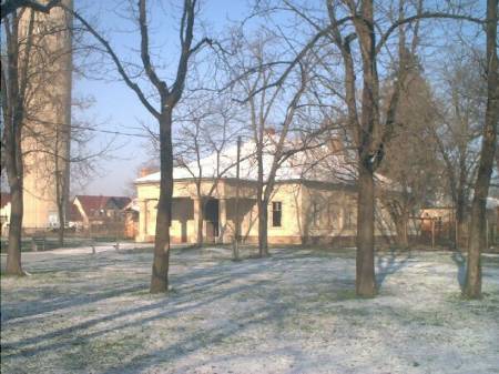
A 2000 holdas egykori gróf DOrsay-kastélyparkban csak három fa maradt. Egy 200 év körüli kocsányos tölgy (a mai óvoda udvarán) és 2 erdeifenyő. A kastélyt ma a Sárréti Múzeum használja. Sajnos nagyon elhanyagolt állapotban van.
1945 után először a szép, nagy parkja ment tönkre, majd maga az épület is, hiszen volt, amikor tollraktárnak használták. A kastély alatt komoly pincerendszer húzódott.
------------------------------------------------------------------------------------
A kúriát 1800 körül építtette a Wenckheim család, klasszicista-romantikus stílusban.
A Wenckheim unokáját feleségül vevő D'Orsay Emil többször átalakíttatta, stílusát romantikus jegyekkel bővítette. A jellegzetes romantikus díszítést az angol szakállas szemöldökpárkányot adják. 1945 után először a szép nagy parkja ment tönkre, majd maga az épület is, hiszen volt, amikor tollraktárnak használták. A kastély alatt komoly pincerendszer húzódott, ezekhez több hiedelem is fűződik, melyek szerint az alagút a város másik végén lévő Kárász-kastélyba, más verzió szerint a Sebes-Körös-parti Várhelyig vezet.
|
Address: Szeghalom, Nagy M. út 2. |
| Openness for the public: |
| Data sheet of the garden |
|
| | |
| Garden identificaton number: | 1022 |
| Garden name: | Wenckheim-D`Orsay-kastély és kertje ??? |
| Present size of the garden: | ha |
| Country: | Hungary |
| County: | Békés |
| Settlement: | Szeghalom |
| Street: | Nagy M. út 2. |
| House number: | |
| Phone: | n.a. |
| Fax: | |
| Email: | |
| Web site: | muemlekem.hu/muemlek?id=2608http://http://http://http://http://http://www.wenckheim.hu/Szeghalom.htmhttp://http://http:// |
| WGS84 latitude coordinate: | 47.021315 |
| WGS84 longitude coordinate: | 21.175311 |
| National grid X coordinate: | |
| National grid Y coordinate: | |
| Land ownership record: | |
| Owner: | n.a. , , , , , , , , |
| Manager(s), renter(s): | n.a. , , , , , , , , |
| User: | , |
| Present function, usage: | n.a. |
| Openness for the public: | |
| Opening hours: | |
| Visitors per year: | 1990: 1991: 1992: 1993: 1994:
1995: 1996: 1997: 1998: 1999:
2000: 2001: 2002: 2003: 2004:
2005: 2006: 2007: 2008: 2009:
2010: 2011: 2012: 2013: 2014:
2015: 2016: 2017: 2018: 2019:
2020: 2021: 2022: 2023: 2024:
2025: 2026: |
| Garden historical data |
|
| Type: | |
| Style, character: | |
| Special value: | |
| Importance, value: | regional importance |
| Original size of the garden: | ha |
| Year(s) of garden planting: | -
|
| Present state, condition of the garden: | |
| Present structure of the garden: | |
| : | |
| Plant condition: | |
| Plans, maps: | |
| Historic county name: | |
| Historic Monument Data: |
|
| Historic monument number(s): | 845 |
| Historic monument type: | műemlék jellegű |
| Resolution of historic monument: | |
| Description of built objects |
|
| Main building description: | |
| Building time of the principal building: | |
| Condition of the principal building: | |
| Present function of the main building: | |
| Other buildings list: | |
| Main building style: | |
| Nature Conservation data: |
|
| Type of nature conservation: | helyi védettségű terület |
| Nature Conservation code : | 2/1989. (VI.22.) Tr. |
| Natuara2000 area code: | |
| Landscape Data: |
|
| Morphology: | |
| Hydrology: | |
| Plant geography: | |
| Soil: | |
| Climate: | |
| Visual connections: | |
| Landscape Character Area name: | |
| Landscape Character Area type: | |
| | |
| Other: | |
| | |
| Associated persons: | |
| Bibliography: | |
| |
| This page edited by: | kollanyi5, |
| Last modified by: | kollanyi5 2009-05-12 |
|