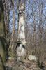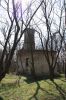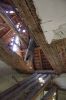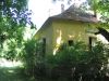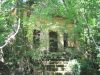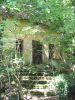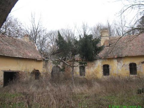
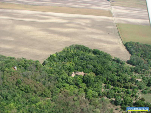
A székesfehérvári kereskedő, Hiemer Sebestyén 1722-ben nősült be a Gindly családba. Fia, Ignác építette ki az uradalmi központot. Kisebb, földszintes, középrizalitos kastély épült ekkor, amelynek falait barokkos zsánerképek borították. A falképek a későbbi átfestések alatt még ma is láthatók helyenként. A kastély körüli gazdasági épületek ma már nincsenek meg. A kastély körüli szép parkban Hiemer Ignác nejével Szentháromságot emeltetett 1802-ben, a kastélytól távolabb, a park végébe építették fel a kápolnát. Később a birtok a Jeszenszky családra szállt, az államosítást megelőzően pedig a Bernáth család tulajdona volt. Visszaemlékezések szerint a régi világban mintagazdaság volt.
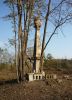
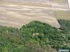
Ma az egész uradalom erősen pusztulófélben van, sorsa reménytelennek tűnik. 2011. októberében a kert egy részét a terület tulajdonosa, a DALMAND ZRT kivágatta, és az ajkai erőműnek adta el. A kiirtott részen, a magában álló Szentháromság-szobor hirdeti a kastély és a birtok egykori fényes múltját és megbecstelenített jelenét.
|
Address: Kölesd (Felsőhídvég) |
| Openness for the public: |
 2011:10:31 14:07:57 A kast??lykert egy r??sz??t 2011. okt??ber??ben kiirtott??k. |
| Data sheet of the garden |
|
| | |
| Garden identificaton number: | 2025 |
| Garden name: | Hiemer-Jeszenszky-Bernáth-kastély |
| Present size of the garden: | ha |
| Country: | Hungary |
| County: | Tolna |
| Settlement: | Kölesd (Felsőhídvég) |
| Street: | |
| House number: | |
| Phone: | |
| Fax: | |
| Email: | |
| Web site: | http://http://http://http://http://http://http://http://http://http://http://http:// |
| WGS84 latitude coordinate: | 46.521400 |
| WGS84 longitude coordinate: | 18.606527 |
| National grid X coordinate: | |
| National grid Y coordinate: | |
| Land ownership record: | |
| Owner: | , , , , , , , , , , , , |
| Manager(s), renter(s): | , , , , , , , , , , , , |
| User: | , |
| Present function, usage: | |
| Openness for the public: | |
| Opening hours: | |
| Visitors per year: | 1990: 1991: 1992: 1993: 1994:
1995: 1996: 1997: 1998: 1999:
2000: 2001: 2002: 2003: 2004:
2005: 2006: 2007: 2008: 2009:
2010: 2011: 2012: 2013: 2014:
2015: 2016: 2017: 2018: 2019:
2020: 2021: 2022: 2023: 2024:
2025: 2026: |
| Garden historical data |
|
| Type: | |
| Style, character: | |
| Special value: | |
| Importance, value: | regional importance |
| Original size of the garden: | ha |
| Year(s) of garden planting: | -
|
| Present state, condition of the garden: | |
| Present structure of the garden: | |
| : | |
| Plant condition: | |
| Plans, maps: | |
| Historic county name: | |
| Historic Monument Data: |
|
| Historic monument number(s): | 8156 |
| Historic monument type: | |
| Resolution of historic monument: | |
| Description of built objects |
|
| Main building description: | |
| Building time of the principal building: | |
| Condition of the principal building: | |
| Present function of the main building: | |
| Other buildings list: | |
| Main building style: | |
| Nature Conservation data: |
|
| Type of nature conservation: | |
| Nature Conservation code : | |
| Natuara2000 area code: | |
| Landscape Data: |
|
| Morphology: | |
| Hydrology: | |
| Plant geography: | |
| Soil: | |
| Climate: | |
| Visual connections: | |
| Landscape Character Area name: | |
| Landscape Character Area type: | |
| | |
| Other: | |
| | |
| Associated persons: | |
| Bibliography: | |
| |
| This page edited by: | kollanyi5, Kun J??zsef, Bern??th Gy??rgy, |
| Last modified by: | Bern??th Gy??rgy 2011-11-03 |
|