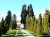
A somogybükkösdi egykori Somssich-kúria parkja belterületi díszkert. A park különleges értékét szép körpanorámás fekvése, a ritka fenyőfajok, az örökzöld bambuszok és két "matuzsálemi" gesztenyefa jelenti. Értékes fafajok az atlanti cédrus, a kolorádófenyő, a kaukázusi jegenyefenyő, a simafenyő, a lucfenyő, a tiszafa, a kislevelű hárs, a tatárjuhar, a madárberkenye.
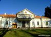
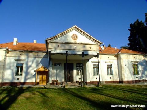
A kastély 1,8 hektáros parkja 1985 óta természetvédelmi terület, a belterületi körpanorámás díszkert. A kert fekvése és az ott található fenyőfajok teszik értékessé Somogybükkösd e kis, örökzöldekkel és lombos fafajokkal telepített területét. A parkban nemcsak fenyőritkaságok, örökzöld bambuszok és gesztenyefa-matuzsálemek találhatók, értékes fafajai: atlanti cédrus, kolorádófenyő, kaukázusi jegenyefenyő, tiszafa, madárberkenye. Itt találhatóak az I. és II. világháborús emlékművek is. |
Address: Somogybükkösd, Fő u. 92. |
| Openness for the public: |
| Data sheet of the garden |
|
| | |
| Garden identificaton number: | 958 |
| Garden name: | Somssich-Perczel kastély és kertje (Petrovszky ???) |
| Present size of the garden: | 1,8 ha |
| Country: | Hungary |
| County: | Somogy |
| Settlement: | Somogybükkösd |
| Street: | Fő u. 92. |
| House number: | |
| Phone: | n.a. |
| Fax: | |
| Email: | |
| Web site: | www.kastelyok-utazas.hu/Lap.php?cId=1479&kId=1479http://http://http://http://http://http:// |
| WGS84 latitude coordinate: | 46.300361 |
| WGS84 longitude coordinate: | 16.986998 |
| National grid X coordinate: | |
| National grid Y coordinate: | |
| Land ownership record: | |
| Owner: | n.a., , , , , , |
| Manager(s), renter(s): | n.a., , , , , , |
| User: | , |
| Present function, usage: | n.a. |
| Openness for the public: | |
| Opening hours: | |
| Visitors per year: | 1990: 1991: 1992: 1993: 1994:
1995: 1996: 1997: 1998: 1999:
2000: 2001: 2002: 2003: 2004:
2005: 2006: 2007: 2008: 2009:
2010: 2011: 2012: 2013: 2014:
2015: 2016: 2017: 2018: 2019:
2020: 2021: 2022: 2023: 2024:
2025: 2026: |
| Garden historical data |
|
| Type: | |
| Style, character: | |
| Special value: | |
| Importance, value: | regional importance |
| Original size of the garden: | ha |
| Year(s) of garden planting: |
|
| Present state, condition of the garden: | |
| Present structure of the garden: | |
| : | |
| Plant condition: | |
| Plans, maps: | |
| Historic county name: | |
| Historic Monument Data: |
|
| Historic monument number(s): | |
| Historic monument type: | |
| Resolution of historic monument: | |
| Description of built objects |
|
| Main building description: | |
| Building time of the principal building: | |
| Condition of the principal building: | |
| Present function of the main building: | |
| Other buildings list: | |
| Main building style: | |
| Nature Conservation data: |
|
| Type of nature conservation: | helyi védettségű terület |
| Nature Conservation code : | 1/1985. (X.1.) Tr. |
| Natuara2000 area code: | |
| Landscape Data: |
|
| Morphology: | |
| Hydrology: | |
| Plant geography: | |
| Soil: | |
| Climate: | |
| Visual connections: | |
| Landscape Character Area name: | |
| Landscape Character Area type: | |
| | |
| Other: | |
| | |
| Associated persons: | |
| Bibliography: | |
| |
| This page edited by: | kollanyi5, |
| Last modified by: | kollanyi5 2009-05-10 |
|