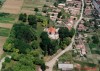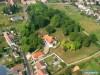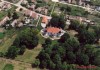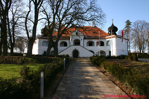
A Borovszky monográfia szerint a kastély négy toronnyal a 17. sz-ban épült. Szombathy Viktor szerint ugyanakkor az 1700-as években emelték barokk stílusban, s az épület az egyik legbájosabb megjelenési formája a vidéki kuriális építkezésnek. Félholdat tartó hagyma alakú saroktornyai afféle török turbánnak hatnak. A nép emlékezet úgy véli, hogy valamelyik török bég építette, azonban ez nem igaz, a Vay-ok hagymakupolái csupán a barokk kor törökös divatját idézik. A mohorai barokk várkastély egy emeletes, a földszintje valójában magas pincesor. Az épület két szélén egy-egy négyzet alapú, zsindelyes-hagymasisakos torony áll. A tornyokat árkádívek kötik össze. (Csáky, 1992) Az épület keskeny aszfaltúton közelíthető meg. Jelenleg magánkézben van, nem látogatható. A közelmúltban teljesen felújították. Az épületet körülvevő park jó állapotban van, gondozott. |
Address: Mohora, Kossuth Lajos u. 2. |
| Openness for the public: |
| Data sheet of the garden |
|
| | |
| Garden identificaton number: | 709 |
| Garden name: | Zichy-Vay kastélypark |
| Present size of the garden: | ha |
| Country: | Hungary |
| County: | Nógrád |
| Settlement: | Mohora |
| Street: | Kossuth Lajos u. 2. |
| House number: | |
| Phone: | |
| Fax: | |
| Email: | mohora@profinter.hu |
| Web site: | www.kastelyok-utazas.hu/Lap.php?cId=553&kId=553http://http://http://http://www.profinter.hu/~mohora/http://http://http://wiki.utikonyvem.hu/hu/index.php?title=Vay-Zichy-kastély_(Mohora)http:// |
| WGS84 latitude coordinate: | 47.992334 |
| WGS84 longitude coordinate: | 19.337783 |
| National grid X coordinate: | |
| National grid Y coordinate: | |
| Land ownership record: | |
| Owner: | , , , , , , |
| Manager(s), renter(s): | , , , , , , |
| User: | , |
| Present function, usage: | |
| Openness for the public: | |
| Opening hours: | |
| Visitors per year: | 1990: 1991: 1992: 1993: 1994:
1995: 1996: 1997: 1998: 1999:
2000: 2001: 2002: 2003: 2004:
2005: 2006: 2007: 2008: 2009:
2010: 2011: 2012: 2013: 2014:
2015: 2016: 2017: 2018: 2019:
2020: 2021: 2022: 2023: 2024:
2025: 2026: |
| Garden historical data |
|
| Type: | |
| Style, character: | |
| Special value: | |
| Importance, value: | local importance |
| Original size of the garden: | ha |
| Year(s) of garden planting: |
|
| Present state, condition of the garden: | |
| Present structure of the garden: | |
| : | |
| Plant condition: | |
| Plans, maps: | |
| Historic county name: | |
| Historic Monument Data: |
|
| Historic monument number(s): | 5711 |
| Historic monument type: | műemlék |
| Resolution of historic monument: | |
| Description of built objects |
|
| Main building description: | |
| Building time of the principal building: | |
| Condition of the principal building: | |
| Present function of the main building: | |
| Other buildings list: | |
| Main building style: | |
| Nature Conservation data: |
|
| Type of nature conservation: | |
| Nature Conservation code : | |
| Natuara2000 area code: | |
| Landscape Data: |
|
| Morphology: | |
| Hydrology: | |
| Plant geography: | |
| Soil: | |
| Climate: | |
| Visual connections: | |
| Landscape Character Area name: | |
| Landscape Character Area type: | |
| | |
| Other: | |
| | |
| Associated persons: | |
| Bibliography: | |
| |
| This page edited by: | kollanyi5, |
| Last modified by: | kollanyi5 2009-07-03 |
|